
This is now unexpectedly a geography blog.
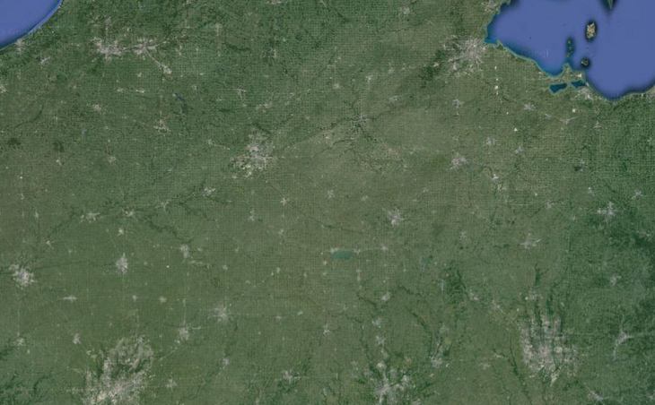
That’s Ohio and Indiana as seen from space.
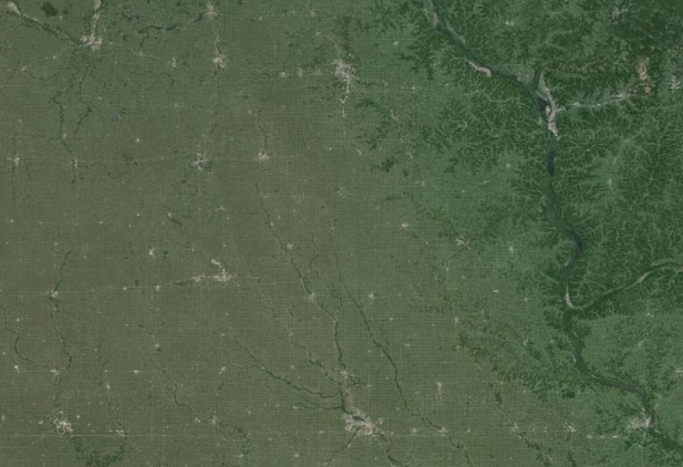
And that’s Northern Iowa and Southern Minnesota as seen from space.
Each small grey dot is a town. Are there straight horizontal or vertical lines that connect more than a chance number of towns? And are the towns arranged in a consistent coordinate grid pattern?
As best I can tell there are a few short straight lines probably representing more-used local roads, but few that persist across entire states. I don’t think there’s any consistent grid pattern. This is the opposite of my initial impression, which was that there was a clear and striking coordinate grid. But when I try to measure the native unit of the coordinate grid, I find that my mind is confusing a whole bunch of vaguely square-ish patterns into one illusory system.
There is a square pattern to the Midwest, deriving from the Public Land Survey System, but its scale is 6 mile x 6 mile squares, which is smaller than any of the distances on either of these maps. There is supposedly a higher level of grid, the 24 mile x 24 mile quadrangle, but it doesn’t seem to be as important and I don’t see that on this map either.
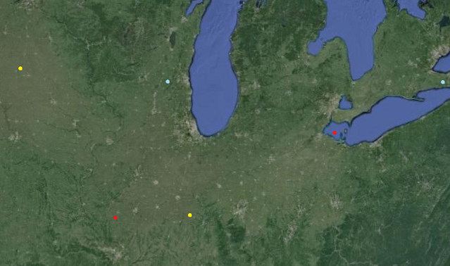
I titled this post “Ley Lines” as a joke, but we might as well see if there are any actual ley lines. The best candidates seem to be the cities between the yellow dots – which are Waterloo, Davenport, Peoria, Bloomington, and Champaign – and the cities between the red dots – which are Springfield, Champaign, Lafayette, Fort Wayne, and Toledo. If you want to stretch it, you could also imagine a horizontal line between the blue dots – Madison, Milwaukee, Grand Rapids, Flint, Sarnia, London, and continuing to Buffalo just off the map.
As far as I know there’s no explanation for any of these – no highways, no rivers, nothing – and they’re all just coincidences.
We had some interesting discussions about Midwestern geography during our last Michigan Rationalist Meetup. My favorite part was learning that the town of Zilwaukee, Michigan was named by two brothers hoping that would-be settlers on their way to Milwaukee would get confused and settle there instead. It sounds like a dumb urban legend, but it was previously admitted to on the Zilwaukee city website. I notice their new website doesn’t mention this, which means either that it’s been disproven or they decided to stop advertising to the world that they’re descended from morons.
[EDIT: And here’s a church website that uses Zilwaukee as a metaphor for the Devil]


I know of a vortex in Selma, Indiana. Is that on a ley line?
You need to forget about highways and look at railroads.
Most towns in the Midwest were platted around proposed or newly-constructed railroads. The Illinois Central was the most extreme example, and actually used the exact same plat map to lay out a couple dozen towns between Chicago and the Kentucky/Missouri line. Hence “Oak Street” and “Locust Street” are always on the opposite side of the tracks as “Walnut Street.”
The variance between town spacing is also a function of railroad geometry. The more intersecting lines you have, the bigger your city gets. Bigger cities, in turn, can serve a wider market area (there’s more stuff there to justify the trip). So, for instance, in the middle of Illinois you have a bunch of small cities slugging it out (Decatur, Danville, Bloomington, Springfield) but as you get closer to the “poles” (Chi and StL) you have a reduction in density before the sprawl starts. Hence Dwight, IL is a truckstop while Joliet (inside the Chicago commutershed) has the historic industrial base.
Paved roads (auto trails) only showed up after the railroads had determined population distribution. US numbered highways followed the paved roads, and Interstates followed the most popular US routes, so you have an iterative winner-take-all system in which the city with favorable rail service in 1885 ends up being the city with a couple of freeways in 1960.
The blue-dot line— Madison, Milwaukee, Grand Rapids, Flint, Sarnia, London, Buffalo—continues due east to Syracuse and Utica.
I believe that Philadelphia, Allentown, Scranton, Binghamton, Syracuse, Kingston also form a line.
The question I’m wondering: how would you find the p-value of a given distribution of points into lines and such? For a perfect grid, you would see how close the points are to fitting on grid points, but with lines — well, you can see how close the points are to best-fit lines, but across a 2-d plane that seems like cheating: you should compare it to the probability of random points generating any sets of line-like arrangements that would be recognizable, not just the ones that they happen to actually form.
I feel like this problem (probability of non-random-looking distribution of points on a plane) must be fairly solvable, but I don’t know enough statistics/probability theory to solve it personally.
I assume that by “p-value,” you mean that you want to analyze the appearance of lines under the null hypothesis of uniform distribution. Let’s start with 3 points. We need a measure L of how line-like the points are. Say, the area divided by the square of the perimeter (L=0 for a line). Either analytically or by sampling, one can determine the distribution of this random variable, and thus build a chart of p-values that tell you how surprising a low value of L is.
For more than 3 points, you can adjust for multiple comparisons. That’s fine if multiple lines show up, but what if 4 points form a line? That is not interesting as 4 separate lines, but because it is stronger evidence of a line. So probably you should introduce a new measure L4 of how close the 4 points are to a line. Perhaps simply the sum of the old L of all 4 subsets of 3 lines.
But should we stop and 4 points? Or should we look at all configurations of 10 points? Literally looking at all subsets of 10 is not computationally tractable. And it leads to a terrible multiple comparisons correction. I worry that the Bonferroni correction is too pessimistic because of the correlations. But whatever procedure you come up with – say, working your way up the number of points by throwing out n-tuples with too high Ln – you can test it on data generated by your null hypothesis to get a p-value.
You can also see diagonal lines of population centers that follow highways and railroads connecting major population centers.
I believe the second volume, “The National Experience, of Daniel Boorstin’s trilogy on the history of the United States has a lot on how Jefferson set about to socially engineer a nation of yeoman farmers by imposing a grid upon the land before anybody had gotten there to survey it. This would allow the federal government to sell small plots of land directly to small farmers instead of selling large chunks of land to middlemen, who would become socially dominant landlords.
In contrast, Latin America was typically divvied up by the King of Spain making vast grants to his supporters based on large-scale geographic features that were known even in Spain.
For example, where I live, the San Fernando Valley, which is a couple of hundred square miles, was a single land grant (and that’s pretty small by Latin American standards). The King of Spain wasn’t irrational: the San Fernando Valley is a clear geographic unit: it’s level land surrounded by steep mountains on about 340 degrees of its perimeter. But it’s too big of a chunk of property for an egalitarian Jeffersonian society to evolve if one guy owns the whole thing.
Economist Hernando de Soto has pointed out that Latin America is still plagued to this day by this non-Jeffersonian system. The King’s land grants were so huge that rich landowners had to let their servants and fieldworkers live on their lands (because they could hardly commute to work from over the horizon). But they typically didn’t give their peons legal title to the small plots they squatted upon. So, Latin America is full of people who inherited their small homes via customary right to squat there, but they don’t have legal title to the land, so they can’t use it as collateral to get a loan.
During the 1780s, Thomas Jefferson imposed a grid system on western lands based on latitude and longitude to make federal lands easy to auction off to small farmers.
Railroads and highways generally were built north-south and (especially) east-west. From Wikipedia:
“As roads have typically been laid out along section boundaries spaced one mile (1.6 km) apart, growing urban areas have adopted road grids with mile-long “blocks” as their primary street network.
“West of the Appalachians, road systems frequently follow the PLSS grid structure (see illustrations of Nebraska [grid] vs North Carolina [nongrid] on left). The results can be 90-degree intersections and very long stretches of straight roads.[8][9]”
Towns flourish best along transportation routes.
Railroads were often granted public land adjacent to their paths. Since land was allotted in squares determined by latitude and longitude, it was easiest in terms of property rights if railroad followed a latitude or longitude rather than cut kitty-corner across Jefferson’s grid.
What is it with America and straight lines that form rectangles? I can’t even list the number of times I’ve gotten lost in NYC because of the grid system. Never had that problem in Bremen.
(I live in NYC now, but the particular office on whose floor I sleep had the good sense to put themselves in a square that is neither a square nor part of the grid system.)
Having been raised in Buenos Aires (which shares the grid pattern of North American cities) I have the reverse complaint about Europe. Getting around an unfamiliar European city requires checking the map all the time; getting around an unfamiliar American city requires only knowing which intersection you are going to.
(I guess finding your way by driving in American cities gets more difficult if the streets are not named by numbers like in NY and the numeration is not clearly visible from the car. It is amusing that in this respect, and only in this one, European cities are more car-friendly and American cities more walk-friendly.)
Cities in the U.S. vary widely. Santa Barbara has mostly or all named streets, and while this may have changed since I lived there (though I doubt it), the street signs were remarkable for how hard they were to read. It is, fortunately, a fairly small city, but still, navigating it was needlessly difficult. Other cities have strange quirks. Minneapolis has a mix of numbered and named streets, on a double grid pattern; downtown is a grid of NW/SE and NE/SW streets (all either perpendicular to or parallel to the Mississippi), while the rest of the city is mostly a standard grid of N/S and E/W streets (so all streets that run into downtown bend at the edge of the downtown area; in some cases, they bend in the same direction both times they cross the downtown border, and so run, say, E/W in eastern Minneapolis, NE/SW downtown, and N/S in northern Minneapolis). And there are enough hills and lakes to introduce further complexity as streets divert around things. Still, it’s far more sane than Boston, which defies description. Not all American cities are New York; indeed, New York is unusual in lots of ways.
Can you elaborate a bit more on how the grid system caused you to get lost? I’ve always been confused about how anyone can get lost in Manhattan because I’d think the grid system would make that impossible. And yet my family members do it on a regular basis. So I’m curious what linkage you see there.
I am not nydwracu, but here’s my guess: It’s because with a grid system everywhere looks the same, whereas if you have a more organic layout then there’s more variety. “Oh, wait, I’m at that place where five roads meet. I remember that.”
That’s actually the best guess I could come up with. I think this probably points to a major fault line in the way people navigate. I navigate by “holding a map and knowledge of my Cartesian orientation in my head,” which makes grid systems really easy to navigate. I mostly ignore what things look like, because that’s not relevant to my mental map.
I’m aware that other people navigate by visual cues, but I don’t really alieve it. (I’m aware that other people respond to visual cues, but I don’t really alieve it. I have a tendency to listen to movies).
The complaints in this thread about the reverse situation remind me of this image macro, which has been a popular meme among my Facebook friends (I live in New England).
See also the top comment on the Imgur page, and several others below it in a similar spirit.
http://xkcd.com/253/ (See title text.)
“Never had that problem in Bremen.”
Well it takes a lot more confusion to get lost in a little place like Bremen after all.
The main plan of German cities that started from villages accreting around missionary churches, which is all of them but the few that were Celtic oppida before the Roman conquest, is a star-shaped net of avenues leading out from the central square and cathedral. If you get lost, the first thing to do is to head inward to the center of town, because all the roads out originate there.
NYC is the opposite; it has no center. It is the 19th century equivalent of LA.
You’d love San Francisco. Downtown is two grids which meet at about 45 degrees; the northern one which is almost, but not quite, oriented to the cardinal compass directions, but all the streets have non-sequential names. The grid to the south has numbered streets in one direction and non-sequential names in the other.
South of that, the South of Market grid bends around until it’s almost north-south-east-west, with 3rd street crossing all the streets above 15th at right angles. Further south, there’s another grid, which is about 20 degrees off the cardinal directions; here the streets are alphabetical in *both* directions.
The western half of the City has a grid over most of its area, once again, not *quite* in the cardinal directions. The north-south streets are numbered “Avenues” (repeating numbers used in the numbered “Streets” on the east side), while the east-west ones are alphabetical. Except the streets which border Golden Gate Park.
That might be clearer with a picture. (more cities, zoomable)
Just out of curiosity, if you placed a large number of towns in a random pattern, what is the probability that these sorts of lines would still appear?
Assuming a Poisson distribution, quite low. Randomness in this case would produce a number of tightly clustered towns all in the same place, as well as a number of regions with no towns at all. (https://telescoper.files.wordpress.com/2009/04/pointa.jpg?w=450&h=393)
These town locations are quite clearly constrained in some way, if you have an eye for what real randomness looks like. Which makes sense, because people aren’t going to start a new town without giving any consideration to where other towns are.
Poisson disk is more appropriate.
+1 for teaching me a Thing. Thanks!
See also: http://bost.ocks.org/mike/algorithms/ with a clever algorithm for doing Poisson disc sampling and some pretty visualizations.
What methods of distributing towns randomly would expect as many lines of towns as we observe?
Between the yellow dots at least – I’d bet there used to be a road all the way there (or at least most of the way).
For example, look at this place : https://www.google.fr/maps/@41.5370899,-91.1420901,1373m/data=!3m1!1e3 two roads heading straight for each other at cedar creek, but no bridge; that place was probably a ford in the past (or maybe there used to be a bridge?).
And if you zoom out that road links (linked) Iowa City and Muscatine, which are on Scott’s line between the yellow dots (Muscatine is where that line would cross the Mississippi, unless it crosses at Davenport, which would also kinda work).
Anyway, I would be that the main roads in that area used to be diagonal, but that property rights (and possibly competition from the railroads?) made those roads give way to the rectangular grid, leaving only the pattern of towns as a clue of where the roads used to be. And further out west, maybe the rectangular grid pattern was already established enough (throughout the US) when the towns were founded.
A failed hypothesis: I thought the “ley line” towns would show up as being on the same early railroad lines. This isn’t really true (it’s mostly true for the red line, but not at all for the other two), but I thought I should mention that I tried this under the principle of “publish your negative results”.
Anyway, here’s what I turned up:
[London is not included because my railroad maps don’t include Canada]
In 1860 the railroad lines were fairly sparse, but still went to every town listed except Flint. There is a direct line from Toledo to Fort Wayne that forks after Ft Wayne and goes on (in one fork) to Lafayette and Springfield, so the red line actually does seem to correspond to an early rail route (but Champaign shouldn’t be on it). The yellow and cyan ley lines do not have any direct railroad lines between any pair of cities (unless you count a trip from Milwaukee to Madison via what might be Fort Atkinson).
In 1870 there are many more rail lines, but but the only additional direct line between cities of interest is one from Milwaukee to Madison; every other non-red connection still involves switching lines somewhere.
In 1880 rail lines are thick on the ground and there are some additional connections, but with so many railroads and the lines still incomplete, I’d say it’s pretty clear that the cyan and yellow lines should not be considered to correspond to early railroads. (There is now a Peoria-Bloomington-Champaign connection, and a Waterloo-Davenport connection, but Davenport-Peoria still requires an out of the way transfer; There is also a Flint-Sarnia connection, but Grand Rapids is connected to Detroit, not Flint/Sarnia)
I see rows, but not columns.
Counties in Iowa (and to a lesser degree in other Midwestern states) do form something like a grid, and county seats were sometimes chosen to be near the centre of a county (and subsequently grew due to being administrative centres and Schelling points). This could make the distribution of significant towns somewhat more grid-like than one would expect at random, though there are more than enough odd-shaped counties and off-centre county seats to ensure there’s no actual consistent grid.
Of course, it’s not actually possible to have a perfect grid on the surface of a sphere, and the Public Land Survey grid has occasional jogs in it in order to maintain 6×6 mile squares with parallel north-south sides.
Roads and railroads that cut diagonally to the grid have tended to face greater political opposition than those following the grid, due to disruptively splitting up more farms.
It makes sense that Zilwaukee would be a metaphor for the Devil, given it’s only ninety minutes’ drive from Hell.
Mr. PiBB was first formulated in Zilwaukee in 1972.
The name Dr Pibb was to avoid claims of trademark infringement.
If you want to fool people into thinking they’re settling in Milwaukee, why not name your city “Milwaukee”? I don’t know how many people you’d fool, but presumably more than if you just hope everybody forgets the first letter of the city they’re headed to.
The “descended from morons” bit is rather harsh, given that (allegedly) at least one Jewish immigrant ended up in Ireland rather than America by mistaking “Cork” for “New York”.
If you had non-English speaking immigrants, the “Milwaukee/Zilwaukee” confusion would work better, I think. And besides, American names are odd enough that even non-American speakers of English would have a good chance of getting confused about what that odd-named city was supposed to be called?
And I see by the church website, this was deliberately done at the time of large-scale German immigration, so yep, looks like they were counting on confusion by non-English speakers in a foreign land where the maps were still not wholly reliable:
A large German migration was taking place in the 1840s and Milwaukee was fast becoming an attraction for new immigrants.
Besides, even today, if any of you were plonked down in my neck of the woods, how confident would you be of knowing the difference between Killeagh, Killeagh and Killeagh? Three different places, one west, one east, and one north-west of me?
This author says he once tried booking a flight to Granada, Spain, and wound up on the island of Grenada: http://books.google.com/books?id=w8pWZ2AGI4MC&printsec=frontcover&source=gbs_atb#v=onepage&q=grenada&f=false
I will freely admit that I have gotten sufficiently confused about directions that I once spent over an hour trying to buy a ferry ticket to the Greek island of Paros when I was, in fact, on Paros the whole time.
That’s only slightly more confusing than the next town over from me being named Ballysadare, Ballisodare, and Baile Easa Dara, and slightly less confusing than the 71 streets in Atlanta (where I lived as a teenager and learned to drive) called some variation of Peachtree Street, Old Peachtree Road, Peachtree Circle, and so forth.
When I moved here I was confused enough by North Bend being south of me… then learned of two places with the exact same name, one with an I and one with a Y and decided the North Bend thing was nit such a big deal.
There’s also the town of Eastchester, which is in the county of Westchester, in New York
I once got lost on the way to a robotics conference (really) because, to get to the building, I had to turn on a road with some particular name that I have long since forgotten, and there was another completely different road with the exact same name right before it.
And here’s me thinking it was spelled Ballysodare 🙂
My home town had a Riverside Drive, which:
1) Was nowhere near the river. It ran alongside a stream.
2) Kept appearing and disappearing along the length of this stream. Still with the same name.
Or Milwaukie? (Though that one’s too far away to really confuse people headed for Wisconsin.)
I for one welcome your transition to Geography Blog right at the beginning of Geography Awareness Week.
There’s a Geography Awareness Week? I had no idea.
Insert obvious joke here.
Is the obvious joke “Jeez where have you been?”
Have you been under a rock? No wait that one’s for Geology Awareness Week.
The obvious joke I had in mind was something along the lines of “I wasn’t aware of it, so I guess it must not be working very well.”
We need an Awareness Week Awareness Week.
Perhaps it already exists and we just haven’t noticed.
You’re right; clearly an Awareness Week Awareness Week Awareness Week is called for.
The moral, like in Lewis Carroll’s Tortoise and Achilles dialogue, is that if someone is determined not to pay attention you won’t make them aware no matter how much you recurse.
Yep:
The National Geographic has run it for longer than I’ve been alive. My school is hosting a week-long series of lectures on the geography of beer, fast food, foods of other cultures, etc, and a map exhibition (with the strong subtext of “You can [i]major[/i] in geography, and [i]get a job that pays well[/i], please see our undergrad advisor about changing your major.”)
But yeah, it’s mostly in academia with the exception of GIS Day which has a large number of government jobs, so local governments (at least in Southern California) hold Open Houses with their GIS sections on display so taxpayers can see what kind of capability their local government has. It’s more fun than it sounds, but then again I’m an aspiring professional mapmaker, so I may be biased.
Where do you get satellite photos? I just tried a bunch of mapping websites and none of them seemed have the option to remove the road overlay.
Google Maps. If you’re in Classic View, then on the top right there’s a button that says “Traffic”. If you click on it it’ll give you options about what to show and hide.
The key point was that I didn’t know how to get to classic mode. I found sources saying to click on the question mark, but they put it in the wrong place, so I assumed it had gone away.
If I remember my geography properly, in the absence of other geographic reasons for town placement (water, mountains, resources) in an idealised model where economic activity is the main factor, towns will grow in a geometric pattern. Though this is generally hexagonal, for voronoi/circle-packing/sphere-of-influence type reasons. Maybe look for hexagons?
http://en.m.wikipedia.org/wiki/Central_place_theory
As modeled by Civilization!
Speaking of Geography Blogs, one of my favorites has two recent posts about Milwaukee:
http://www.howderfamily.com/blog/milwaukie/
http://www.howderfamily.com/blog/colonias/
Well, I’d say there’s something to the grid idea, but it’s rather loose. The midwest has far fewer geological features which might require the rerouting of roads, so this area of the country tends to lay out its street and highway plans on more of a grid than most. Add in that for small to midsize towns, there is a sort of midrange opposing magnetism, you don’t need two similar towns right next to one another. There would seem to be an equilibrium of say, ten miles distance for small towns and thirty for midsize ones. Of course, there are a million exceptions to this, especially when dealing with suburban sprawl around large cities, or port towns, etc. Regardless, for the outlying countryside, one would expect small and midsize towns to cluster at busy crossroads and keep a certain distance from each other, leading to a grid pattern.
If distances between towns are what matter, why wouldn’t the pattern be a hex grid?
Well it would ordinarily, and I would suspect that that is what you’d see in Europe but the Public Land Survey System makes square roads more likely. Most of the roads end up laying between two plots on either the north-south line or the east-west line. See here and this map. I think the map in particular is interesting.
Edit: You do see a more hex-like pattern in Europe: see this map of France for an example.
The distance via road is what matters, the layout of the roads is a function of geology and politics. I addressed this in the first bit of my comment. The midwest gets a pretty grid-like distribution of roads. No one is going to place a town in the middle of a field just to meet an arbitrary distance. Crossroads are natural points for towns. It’s the driving distance that incentivizes businesses to locate in a town. Beyond about ten miles (and I’m pulling that number out of my ass as an example), with midwestern population density, you have the customer base for your basic small town. A bank, fast food, hardware, etc. Out west you get much further distances between towns because the population density is lower, on the seaboards, you almost never leave town, because it is so much higher.
“The distance via road is what matters,”
When this stuff was being laid out the only thing that mattered was ease of surveying. The area was basically trackless wilderness by this time (Earlier it had been farmed and settled, but there was a big die-off.)
“No one is going to place a town in the middle of a field just to meet an arbitrary distance.”
This was not a consideration when the area was basically trackless wilderness, especially since the flatness of the terrain permits siting a town, building a road, or platting fields out just about any way people felt like doing it.